


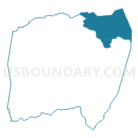
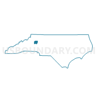
Voting District G1, Alexander County, North Carolina
About
Outline

Summary
| Unique Area Identifier | 639254 |
| Name | Voting District G1 |
| County | Alexander County |
| State | North Carolina |
| Area (square miles) | 25.42 |
| Land Area (square miles) | 25.40 |
| Water Area (square miles) | 0.02 |
| % of Land Area | 99.92 |
| % of Water Area | 0.08 |
| Latitude of the Internal Point | 36.00729640 |
| Longtitude of the Internal Point | -81.04594760 |
Maps

Graphs
Select a template below for downloading or customizing gragh for Voting District G1, Alexander County, North Carolina


Neighbors
Neighoring Voting District (by Name) Neighboring Voting District on the Map
- Voting District 103, Wilkes County, NC
- Voting District 112, Wilkes County, NC
- Voting District G2, Alexander County, NC
- Voting District NH, Iredell County, NC
- Voting District S1, Alexander County, NC
- Voting District SL, Alexander County, NC
Top 10 Neighboring County Subdivision (by Population) Neighboring County Subdivision on the Map
- Sharpes township, Alexander County, NC (5,154)
- Moravian Falls township, Wilkes County, NC (3,007)
- Gwaltneys township, Alexander County, NC (2,252)
- New Hope township, Iredell County, NC (1,662)
- Sugar Loaf township, Alexander County, NC (1,326)
- Brushy Mountain township, Wilkes County, NC (551)
Top 10 Neighboring Unified School District (by Population) Neighboring Unified School District on the Map
- Iredell-Statesville Schools, NC (131,920)
- Wilkes County Schools, NC (69,340)
- Alexander County Schools, NC (37,198)
Top 10 Neighboring State Legislative District Lower Chamber (by Population) Neighboring State Legislative District Lower Chamber on the Map
- State House District 94, NC (69,340)
- State House District 92, NC (68,165)
- State House District 88, NC (67,590)
Top 10 Neighboring State Legislative District Upper Chamber (by Population) Neighboring State Legislative District Upper Chamber on the Map
Top 10 Neighboring 111th Congressional District (by Population) Neighboring 111th Congressional District on the Map
Top 10 Neighboring Census Tract (by Population) Neighboring Census Tract on the Map
- Census Tract 9612, Wilkes County, NC (7,171)
- Census Tract 9610.02, Wilkes County, NC (5,241)
- Census Tract 402, Alexander County, NC (3,994)
- Census Tract 401, Alexander County, NC (3,476)
- Census Tract 609.01, Iredell County, NC (3,186)